Mount St. Helens - Worm Flows Route - 4/7/2021
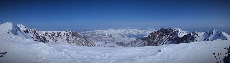
Default and most direct route for winter climbing | Highly recommend avalanche training and how to ready map | Ice axe, Crampons | Carry plenty of water | will run into lot of skier/snowboarders | To reduce your exposure to avalanche potential, stay away from snow loaded slopes and gully bottoms. Stay off the cornices at the crater rim
Views: Priceless; several mountain views including Mt. Rainier, Mt. Adams, Mt. Hood.
Area: South Cascades, Washington
Trailhead: At the parking lot of Marble Mountain Sno-Park.
Pass: National Monument Fee, Sno-Parks Permit | Sno-Park passes required between December 1 - March 31, must be purchased in-person at a retailer. Not available online nor at the trailhead | Climbing permits required, by advance purchase only, between April 1 - November 30.
Stats: 12.0 miles, roundtrip; Elevation Gain: 5699 ft. Highest Point: 8364 ft.
Journey:
It is a long drive from Redmond, WA to the trailhead - 4hours 30 minutes. Arrived the parking lot at 5 am with a friend. Took an hour to get ready and hit the trailhead. We suited with crampon right from the trailhead as there was solid snow right from there. Ran into very few people. The first two miles was a stroll in the park with just 900 ft elevation gain up from the trail head ( 2800 ft.) until Chocolate falls (3700 ft). No views until this point but enjoy the gradual walk because you got to a grueling ~4 miles and ~4650 feet climb ahead of you after the Chocolate falls tree line. There is a wooden signpost guide climbers from timberline to approximately 4,800 ft. elevation. This is the point where you will need a climber's permit to go past beyond this point. As you go up there are grueling hills that you have to climb and multiple falls summits. At every false summit, you feel like giving up. Just gather your strength, drink some water, get some snacks and put one foot in front of the other until you reach the summit at 8313 feet. The route crests the crater's crescent-shaped rim, on a clear day revealing dramatic views of Spirit Lake and Mount Rainier. Head west along the rim to the true summit, a 1/4 mile away at 8,363 feet. But be careful - most winters getting true summit is very dangerous and may not be worth it. There is no new view that will miss from the true summit that you have not seen from the rim.
Personally, the return trip is more fun for me that the climb up. There is plenty of glissading opportunities. But you have to take caution. Glissading is fun and saves a ton of energy and cuts the time you get down from the mountain but is equally dangerous. Few tips on glissading:
put your helmets on; remove your crampons.
wear your rain paints.
pack everything in your bag safely. no loose objects.
use your ice axe as a paddle to control the direction and speed.
Just be very very careful. If you cannot see where you are heading don't glissade.
Lastly keep checking your route map to make sure you are traversing the path back to marble mountain trailhead.
Have safe fun!!!


Comments